Within a week, China has added two more satellites to its network of military satellites. The first on October 15th was Shijian 16, the next-generation of electronic / signals intelligence (ELINT / SIGINT) satellites.
The Shijian 16 is the first of a new series that will succeed the Shijian 6 series, which consisted of four pairs with two satellites each. The Shijian 6 satellites were launched between 2004 and 2010.
The second satellite to be launched was the Yaogan 18 on October 29th. The Yaogan 18 is a Synthetic Aperture Radar (SAR) satellite, similar to Yaogan 6 and Yaogan 13 that preceded it.
The SAR satellites complement imagery provided by other Yaogan
satellites equipped with an optical payload. They tend to have lower
resolution, but do not suffer from some of the restrictions that limit
the latter.
Showing posts with label Satellites. Show all posts
Showing posts with label Satellites. Show all posts
Wednesday, October 30, 2013

Tuesday, September 3, 2013
China Launches Yaogan 17 ELINT / SIGINT Satellites
China added Yaogan 17, a group of three Electronic / Signals Intelligence satellites, to its network of military satellites on September 1 (September 2 local time). It is the third in a series, which was preceded by Yaogan 9 on March 2010 and Yaogan 16 on November 2012.
The cluster of satellites can be used in conjunction to analyse and locate the position of various objects based on their electronic emissions and the time difference of arrival technique in a manner reminiscent of the United States Naval Ocean Surveillance System (NOSS).
Another significant development is China's demonstrated ability to orbit satellites with much enhanced ability to maneuver in space and in a very precise manner.
Unlike most satellites which tend to follow a fixed orbit for most of their life span and have very rudimentary maneuverability, these satellites are closer to unmanned aircraft which can change their orbit in space periodically and on demand.
The cluster of satellites can be used in conjunction to analyse and locate the position of various objects based on their electronic emissions and the time difference of arrival technique in a manner reminiscent of the United States Naval Ocean Surveillance System (NOSS).
Another significant development is China's demonstrated ability to orbit satellites with much enhanced ability to maneuver in space and in a very precise manner.
Unlike most satellites which tend to follow a fixed orbit for most of their life span and have very rudimentary maneuverability, these satellites are closer to unmanned aircraft which can change their orbit in space periodically and on demand.
Friday, July 26, 2013
UAE Buys 2 Optical Satellites From France
The United Arab Emirates (UAE) has signed a contract in Abu Dhabi with France for the delivery of two optical reconnaissance satellites. The Falcon Eye satellite contract is valued at about 700 million Euros or about $900 million.
The decision had come down between France and the United States after several other countries has been eliminated earlier. The United States was led by Lockheed Martin.
The contract will be executed by Astrium, a subsidiary of of EADS, and Thales Alenia Space, a joint venture between French Thales and Italian Finmeccanica. The two high-resolution Pléiades-class satellites will be delivered in 2017 and 2018.
The UAE contract is a much needed win for France, whose defense orders fell by over 25 percent in 2012. It may also help boost cooperation between France in the UAE on defense matters.
In addition to building the satellites and related control station, France will also launch the satellites into orbit. France will also assist with image processing software, transmission and encryption systems and intelligence interpretation and analysis training.
Although optical reconnaissance and surveillance satellites suffer from some drawbacks such as susceptibility to weather conditions, they've become much more affordable in recent years.
It is now possible for countries and even private companies to get their own highly detailed images that were impossible to obtain several decades ago except for a few intelligence services.
http://uk.finance.yahoo.com/news/uae-buys-two-french-surveillance-164255629.html
The decision had come down between France and the United States after several other countries has been eliminated earlier. The United States was led by Lockheed Martin.
The contract will be executed by Astrium, a subsidiary of of EADS, and Thales Alenia Space, a joint venture between French Thales and Italian Finmeccanica. The two high-resolution Pléiades-class satellites will be delivered in 2017 and 2018.
The UAE contract is a much needed win for France, whose defense orders fell by over 25 percent in 2012. It may also help boost cooperation between France in the UAE on defense matters.
In addition to building the satellites and related control station, France will also launch the satellites into orbit. France will also assist with image processing software, transmission and encryption systems and intelligence interpretation and analysis training.
Although optical reconnaissance and surveillance satellites suffer from some drawbacks such as susceptibility to weather conditions, they've become much more affordable in recent years.
It is now possible for countries and even private companies to get their own highly detailed images that were impossible to obtain several decades ago except for a few intelligence services.
http://uk.finance.yahoo.com/news/uae-buys-two-french-surveillance-164255629.html
Thursday, May 16, 2013
China Tests Possible Future ASAT Missile Interceptor
China has tested a next-generation missile that could be used to target satellites that are much higher in orbit than previously possible. While the test did not target any satellites, it did reach an altitude above 10000 km.
Officially, the test involved a sounding rocket for scientific purposes. However, the manner in which the test was conducted strongly suggested it was connected to the Chinese military.
In some ways, the latest test was not that much of a surprise, but a logical evolution of previous capabilities. In 2007, a weather satellite was intercepted by a direct-ascend interceptor using hit-to-kill technology.
With hit-to-kill, the payload will destroy the target using the force from kinetic impact. It is much more technically challenging than previous warheads that relied on proximity fuses.
The satellite intercepted was at an orbit of around 865 km meaning that China has the ability to intercept most reconnaissance satellites that are at lower altitudes.
China also successfully tested its ability to intercept long-range ballistic missiles outside the atmosphere. Such a test came as recently as January of 2013 again using the same hit-to-kill technology used earlier.
However, the latest missile was able to reach much higher than before. It could possibly bring into range all satellites, not just those in low earth orbit but also those in medium earth orbit and geostationary earth orbit.
In medium earth orbit are the GPS satellites and in geostationary earth orbit are military communications satellites. These are high-value assets with significant ramifications if they were to be disabled.
http://news.yahoo.com/china-missile-hit-highest-suborbital-level-since-1976-053335882.html
Officially, the test involved a sounding rocket for scientific purposes. However, the manner in which the test was conducted strongly suggested it was connected to the Chinese military.
In some ways, the latest test was not that much of a surprise, but a logical evolution of previous capabilities. In 2007, a weather satellite was intercepted by a direct-ascend interceptor using hit-to-kill technology.
With hit-to-kill, the payload will destroy the target using the force from kinetic impact. It is much more technically challenging than previous warheads that relied on proximity fuses.
The satellite intercepted was at an orbit of around 865 km meaning that China has the ability to intercept most reconnaissance satellites that are at lower altitudes.
China also successfully tested its ability to intercept long-range ballistic missiles outside the atmosphere. Such a test came as recently as January of 2013 again using the same hit-to-kill technology used earlier.
However, the latest missile was able to reach much higher than before. It could possibly bring into range all satellites, not just those in low earth orbit but also those in medium earth orbit and geostationary earth orbit.
In medium earth orbit are the GPS satellites and in geostationary earth orbit are military communications satellites. These are high-value assets with significant ramifications if they were to be disabled.
http://news.yahoo.com/china-missile-hit-highest-suborbital-level-since-1976-053335882.html
Monday, March 11, 2013
Two more SBIRS satellites and additional tests of LRASM missile
The Defense Advanced Research Projects Agency (DARPA) has awarded a $71 milion contract to Lockheed Martin to conduct air and surface-launched flight tests of the Long Range Anti-Ship Missile (LRASM).
As part of this contract, an additional air-launched LRASM flight test will be conducted from a B-1B bomber in 2013. Two air-launched flight tests were already scheduled for 2013 under an earlier contract. Two surface-launched LRASM flight tests are scheduled for 2014.
The LRASM is a stealthy, autonomous, subsonic anti-ship cruise missile based on the AGM-158 JASSM-ER. It can be launched from both aircraft and warships. A supersonic variant othe LRASM was initially proposed, but later cancelled.
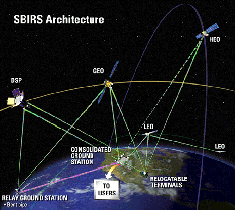
The United States Air Force has also awarded a $284.4 million contract to procure long lead parts for the fifth and sixth Geosynchronous Earth Orbit (GEO) satellites that are part of the Space Based Infrared System (SBIRS) satellite constellation.
The SBIRS constellation consists of Highly-elliptical Earth Orbit (HEO) satellites in addition to the GEO satellites and provide early missile warning of ballistic missile launched.
So far, 4 HEO satellites and 6 GEO satellites are to be acquired. Of these, 2 HEO satellites and 1 GEO satellite have already been launched into orbit. A second GEO satellite is scheduled to be launched in March 2013.
http://www.lockheedmartin.com/us/news/press-releases/2013/march/mfc-030413-LM-Receives-71million.html
http://www.lockheedmartin.com/us/news/press-releases/2013/march/March52013.html


As part of this contract, an additional air-launched LRASM flight test will be conducted from a B-1B bomber in 2013. Two air-launched flight tests were already scheduled for 2013 under an earlier contract. Two surface-launched LRASM flight tests are scheduled for 2014.
The LRASM is a stealthy, autonomous, subsonic anti-ship cruise missile based on the AGM-158 JASSM-ER. It can be launched from both aircraft and warships. A supersonic variant othe LRASM was initially proposed, but later cancelled.
The United States Air Force has also awarded a $284.4 million contract to procure long lead parts for the fifth and sixth Geosynchronous Earth Orbit (GEO) satellites that are part of the Space Based Infrared System (SBIRS) satellite constellation.
The SBIRS constellation consists of Highly-elliptical Earth Orbit (HEO) satellites in addition to the GEO satellites and provide early missile warning of ballistic missile launched.
So far, 4 HEO satellites and 6 GEO satellites are to be acquired. Of these, 2 HEO satellites and 1 GEO satellite have already been launched into orbit. A second GEO satellite is scheduled to be launched in March 2013.
http://www.lockheedmartin.com/us/news/press-releases/2013/march/mfc-030413-LM-Receives-71million.html
http://www.lockheedmartin.com/us/news/press-releases/2013/march/March52013.html

Monday, December 10, 2012
Chinese Long March series of rocket launch vehicles
The Long March series of rocket launch vehicles are developed by the China Academy of Launch Vehicle Technology. All vehicles carry the CZ designation, which becomes LM for foreign audiences.



Long March LM-2C / CZ-2C rocket series
The LM-2C series comes in two and three stage versions. It has a total length of 43 m and a core stage diameter of 3.35 m. The fairing is 8 m long and 3.35 m in diameter. Liftoff mass is 245 ton and liftoff thrust is 2962 kn. Low Earth Orbit (LEO) payload capacity is 3850 kg. The LM-2C/CTS has a Sun-Synchronous Orbit (SSO) payload capacity of 1900 kg (600 km) and a Geostationary Transfer Orbit (GTO) payload capacity of 1200 kg. The LM-2C series has been used to launch recoverable satellites, ocean satellites and Iridum satellites.
Long March LM-2D / CZ-2D rocket series
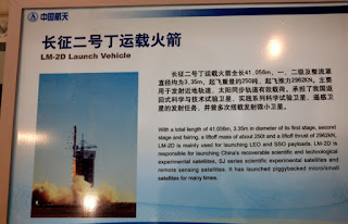
The LM-2D series is used for LEO and SSO payloads and has a total length of 41.056 m, a diameter of 3.35 m for both stages and fairing, a liftoff mass of about 250 ton and a liftoff thrust of 2962 kn. The LM-2D series has been used for recoverable scientific and experimental technological satellites, SJ series experimental scientific satellites and remote sensing satellites and other piggybacked small and micro satellites.
Long March LM-2F / CZ-2F rocket series
The LM-2F series comes in two versions for manned space launch and target vehicle. It has a length of 58 m for manned launches and 52 m for target vehicles. It has a core stage diameter of 3.35 m, a booster diameter of 2.25 m, a liftoff mass of 498 ton, a liftoff thrust of 5923 kn and a LEO payload capacity of 8100 kg for manned vehicles and 8600 kg for target vehicles. The LM-2F series has been used for 10 launch missions, including 5 unmanned missions, 4 manned missions and 1 Tiangong target vehicle.
Long March LM-3A / CZ-3A rocket series
The LM-3A series has a total length of 52.5 m, a core stage diameter of 3.35 m, a fairing diameter of 3.35 m, a liftoff mass of 241 ton, a liftoff thrust of 2962 kn and a GTO payload capacity of 2600 kg. The LM-3A series is used for GSO payloads such as FY meteorological satellites, Beidou navigation satellites and Chang'e-1 lunar probe.
Long March LM-3B / CZ-3B rocket series
The LM-3B series has a total length of 56.3 m, a core stage diameter of 3.35 m, four strap-on boosters of 2.25 m in diameter, a fairing diameter of 4 m or 4.2 m, a liftoff mass of 456 ton, a liftoff thrust of 5923 kn and a GTO payload capacity of 5500 kg. The LM-3B series is mainly used for GSO payloads and is the main launch vehicle for international commercial launch services. The LM-3B series has been used for 20 foreign and domestic communication satellites such as VeneSat-1, PakSat-1R, NigcomSat-1R, W3C and Apstar-7.
Long March LM-4C / CZ-4C rocket series
The LM-4B/LM-4C series has a total length of 46.949 m, a diameter of 3.35 m for the first 2 stages and a diameter of 2.9 m for the 3rd stage, a fairing diameter of 2.9 m / 3.35 m / 3.8 m, a liftoff mass of about 250 ton and a liftoff thrust of 2962 kn. The LM-4B/LM-4C series are mainly used for SSO payloads and have been used for the ZY satellite series, Brazilian experimental scientific satellites, HY satellite series, SJ satellite series, Yaogan satellite series and other piggybacked small / micro satellites.
Long March LM-5 / CZ-5 rocket series
The LM-5 series has a total length of 57 m, a core stage diameter of 5 m, a booster diameter of 3.35 m and a fairing diameter of 5.2 m. The basic version is a 2.5 stage liquid launch vehicle with 4 strap-on boosters and has a liftoff mass of 867 ton, a liftoff thrust of 10565 kn, a GTO payload capacity of 14 ton and a LEO payload capacity of 25 ton. The LM-5 series can be used to launch various kinds of spacecraft such as LEO and GTO satellites, space stations and lunar probes.
Saturday, December 1, 2012
China's Military Satellite Network List Detailed
The People's Republic of China operates an extensive network of military satellites. The list below includes satellites which are known to be dedicated to military use.
Their use includes secure communications, electronic / signals intelligence (ELINT / SIGINT), early warning, ground / earth mapping, data relay and optical / Synthetic Aperture Radar (SAR) reconnaissance.
Not included are dual-use satellites which may perform some military use, but are not strictly so in nature. Not included therefore are the Beidou navigation satellites.
While not strictly military in nature due to their role in civilian use, the Beidou satellites are a crucial asset to the military.
Their use includes secure communications, electronic / signals intelligence (ELINT / SIGINT), early warning, ground / earth mapping, data relay and optical / Synthetic Aperture Radar (SAR) reconnaissance.
Not included are dual-use satellites which may perform some military use, but are not strictly so in nature. Not included therefore are the Beidou navigation satellites.
While not strictly military in nature due to their role in civilian use, the Beidou satellites are a crucial asset to the military.
Shentong strategic communications satellites
| Launch date | Name | Launcher | Type | Notes |
| 11/14/2003 | Chinasat 20 or Shentong 1-1 | CZ-3A | Strategic communications | - |
| 11/25/2010 | Chinasat 20A or Shentong 1-2 | CZ-3A | Strategic communications | - |
| 05/26/2012 | Chinasat 2A or Shentong 2 | CZ-3B/E | Strategic communications | - |
Fenghuo tactical communications satellites
| Launch date | Name | Launcher | Type | Notes |
| 01/26/2000 | Chinasat 22 or Fenghuo 1-1 | CZ-3A | Tactical communications | - |
| 09/12/2009 | Chinasat 22A or Fenghuo 1-2 | CZ-3A | Tactical communications | - |
| 09/19/2011 | Chinasat 1A or Fenghuo 2 | CZ-3B | Tactical communications | - |
Shijian 6 dual electronic / signals intelligence satellites
| Launch date | Name | Launcher | Type | Notes |
| 09/09/2004 | Shijian 6-01A / Shijian 6-01B | CZ-4B | ELINT / SIGINT | - |
| 10/24/2006 | Shijian 6-02A / Shijian 6-02B | CZ-4B | ELINT / SIGINT | - |
| 10/25/2008 | Shijian 6-03A / Shijian 6-03B | CZ-4B | ELINT / SIGINT | - |
| 10/06/2010 | Shijian 6-04A / Shijian 6-04B | CZ-4B | ELINT / SIGINT | - |
Shijian 16 electronic / signals intelligence satellites
| Launch date | Name | Launcher | Type | Notes |
| 10/25/2013 | Shijian 16-01 | CZ-4B | ELINT / SIGINT | - |
Shijian 11 surveillance satellites
| Launch date | Name | Launcher | Type | Notes |
| 11/12/2009 | Shijian 11-01 | CZ-2C | Infrared surveillance | - |
| 07/06/2011 | Shijian 11-02 | CZ-2C | Infrared surveillance | - |
| 07/29/2011 | Shijian 11-03 | CZ-2C | Infrared surveillance | - |
| 08/29/2011 | Shijian 11-04 | CZ-2C | Infrared surveillance | Rocket launch failure |
| 07/15/2013 | Shijian 11-05 | CZ-2C | Infrared surveillance | - |
| 03/31/2014 | Shijian 11-06 | CZ-2C | Infrared surveillance | - |
| 09/28/2014 | Shijian 11-07 | CZ-2C | Infrared surveillance | - |
| 10/27/2014 | Shijian 11-08 | CZ-2C | Infrared surveillance | - |
Tianhui earth mapping satellites
| Launch date | Name | Launcher | Type | Notes |
| 08/24/2010 | Tianhui 1-1 | CZ-2D | Earth mapping | - |
| 05/26/2012 | Tianhui 1-2 | CZ-2D | Earth mapping | - |
Tianlian data relay satellites
| Launch date | Name | Launcher | Type | Notes |
| 04/25/2008 | Tianlian 1-1 | CZ-3C | Data relay | - |
| 07/11/2011 | Tianlian 1-2 | CZ-3C | Data relay | - |
| 07/25/2012 | Tianlian 1-3 | CZ-3C | Data relay | - |
Yaogan / Jian Bing reconnaissance satellites
| Launch date | Name | Launcher | Type | Notes |
| 04/27/2006 | Yaogan 1 | CZ-4B | Synthetic Aperture Radar reconnaissance | Out of service |
| 05/25/2007 | Yaogan 2 | CZ-2D | Optical reconnaissance | - |
| 11/12/2007 | Yaogan 3 | CZ-4C | Synthetic Aperture Radar reconnaissance | - |
| 12/01/2008 | Yaogan 4 | CZ-2D | Optical reconnaissance | - |
| 12/15/2008 | Yaogan 5 | CZ-4B | Optical reconnaissance | Deorbited |
| 04/29/2009 | Yaogan 6 | CZ-2C | Synthetic Aperture Radar reconnaissance | - |
| 12/09/2009 | Yaogan 7 | CZ-2D | Optical reconnaissance | YG2+4 |
| 12/15/2009 | Yaogan 8 | CZ-4C | Optical reconnaissance(?) | - |
| 03/05/2010 | Yaogan 9A, Yaogan 9B, Yaogan 9C | CZ-4C | ELINT / SIGINT | Used to locate and track objects by their electronic emissions |
| 08/10/2010 | Yaogan 10 | CZ-4C | Synthetic Aperture Radar reconnaissance | YG1+3 |
| 09/22/2010 | Yaogan 11 | CZ-2D | Optical reconnaissance | YG2+4+7 |
| 11/09/2011 | Yaogan 12 | CZ-4B | Optical reconnaissance | - |
| 11/30/2011 | Yaogan 13 | CZ-4C | Synthetic Aperture Radar reconnaissance | - |
| 05/10/2012 | Yaogan 14 | CZ-2D | Optical reconnaissance | - |
| 05/29/2012 | Yaogan 15 | CZ-4B | Optical reconnaissance(?) | - |
| 11/25/2012 | Yaogan 16A, Yaogan 16B, Yaogan 16C | CZ-4C | ELINT / SIGINT | - |
| 09/01/2013 | Yaogan 17A, Yaogan 17B, Yaogan 17C | CZ-4C | ELINT / SIGINT | YG9+16 |
| 10/29/2013 | Yaogan 18 | CZ-2C | Synthetic Aperture Radar reconnaissance | YG6+13 |
| 11/20/2013 | Yaogan 19 | CZ-4C | Optical reconnaissance(?) | YG8+15 |
| 08/09/2014 | Yaogan 20A, Yaogan 20B, Yaogan 20C | CZ-4C | ELINT / SIGINT | YG9+16+17 |
| 09/08/2014 | Yaogan 21 | CZ-4B | Optical reconnaissance | YG5+12 |
| 10/20/2014 | Yaogan 22 | CZ-4C | Optical reconnaissance(?) | YG8+15+19 |
| 11/14/2014 | Yaogan 23 | CZ-2C | Synthetic Aperture Radar reconnaissance | YG6+13+18 |
| 11/20/2014 | Yaogan 24 | CZ-2D | Optical reconnaissance | YG2+4+7+11 |
| 12/10/2014 | Yaogan 25A, Yaogan 25B, Yaogan 25C | CZ-4C | ELINT / SIGINT | YG9+16+17+20 |
| 12/27/2014 | Yaogan 26 | CZ-4B | Optical reconnaissance | Succeeds YG5+12+21 |
Monday, November 26, 2012
China launches Yaogan 16 ELINT / SIGINT satellites
On the 25th of November 2012, the Yaogan-16 satellites were launched into orbit by a Long March (Chang Zheng) 4C rocket from the Jiuquan Satellite Launch Center in Jiuquan, northwest China's Gansu Province.
Developed by the China Aerospace Science and Technology Corporation (CASC), the Yaogan 16 consists of a three satellite cluster orbiting in formation in low-earth orbit. They are the second in the series following the launch of Yaogan 9 on March 5, 2010.
Although officially classified as remote-sensing satellites, the Yaogan 16 are Electronic / Signals Intelligence (ELINT / SIGINT) satellites, similar to the Naval Ocean Surveillance System (NOSS) satellite formations used by the United States Navy.
The satellite triplets work together to locate and track objects by their electronic emissions and analyzing them using the Time-Difference-Of-Arrival (TDOA) technique. Intended targets can include warships or Surface-to-Air (SAM) installations among others.
http://news.xinhuanet.com/english/photo/2012-11/25/c_131997696.htm
Developed by the China Aerospace Science and Technology Corporation (CASC), the Yaogan 16 consists of a three satellite cluster orbiting in formation in low-earth orbit. They are the second in the series following the launch of Yaogan 9 on March 5, 2010.
Although officially classified as remote-sensing satellites, the Yaogan 16 are Electronic / Signals Intelligence (ELINT / SIGINT) satellites, similar to the Naval Ocean Surveillance System (NOSS) satellite formations used by the United States Navy.
The satellite triplets work together to locate and track objects by their electronic emissions and analyzing them using the Time-Difference-Of-Arrival (TDOA) technique. Intended targets can include warships or Surface-to-Air (SAM) installations among others.
http://news.xinhuanet.com/english/photo/2012-11/25/c_131997696.htm
Sunday, November 18, 2012
China & Congo Sign CongoSat-1 Satellite Contract at Zhuhai Airshow 2012
At Zhuhai Airshow 2012, the China Great Wall Industry Corporation (CGWIC), a China Aerospace Science & Technology Corporation (CASC) subsidiary, signed a satellite contract with National Network of Satellite Telecommunications of the Democratic Republic of Congo.
The contract will cover all aspects of in-orbit delivery of the satellite, including satellite manufacture, satellite launch, ground control station construction, financing, insurance and training.
The satellite is to be named CongoSat-1 and is based on the DFH-4 satellite platform. The DFH-4 is China's newest generation, Direct Broadcasting Satellite (DBS) with a design lifetime of 15 years.
Launch is scheduled in 2015 and will provide communications services over the Democratic Republic of the Congo and the central and southern parts of the African continent.
Similar contracts have been signed previously and are listed in the table below.
http://www.globaltimes.cn/content/744891.shtml
The contract will cover all aspects of in-orbit delivery of the satellite, including satellite manufacture, satellite launch, ground control station construction, financing, insurance and training.
The satellite is to be named CongoSat-1 and is based on the DFH-4 satellite platform. The DFH-4 is China's newest generation, Direct Broadcasting Satellite (DBS) with a design lifetime of 15 years.
Launch is scheduled in 2015 and will provide communications services over the Democratic Republic of the Congo and the central and southern parts of the African continent.
Similar contracts have been signed previously and are listed in the table below.
| Launched | Name | Country | Notes |
| 05/13/2007 | NigComSat-1 | Nigeria | Solar panels malfunctioned after 18 months of service. |
| 10/29/2008 | VeneSat-1 | Venezuela | - |
| 08/11/2011 | PakSat-1R | Pakistan | - |
| 12/19/2011 | NigComSat-1R | Nigeria | Provided free of charge as replacement for NigComSat-1 |
| 12/20/2013 | Túpac Katari / TKSat-1 | Bolivia | - |
| - | LaoSat-1 | Laos | Launch scheduled in 2015 |
| - | BelarusSat | Belarus | Launch scheduled in 2015 |
| - | NicaSat-1 | Nicaragua | Launch scheduled in 2015 |
| - | SupremeSat III | Sri Lanka | Launch scheduled in 2015 |
http://www.globaltimes.cn/content/744891.shtml
Friday, October 26, 2012
Beidou Navigation Satellite System
The Beidou or Compass Navigation Satellite System is China’s second-generation satellite navigation system currently in the process of being deployed. Building upon the first generation Beidou System, which consisted of just 4 satellites, it is currently one of four navigation satellite systems worldwide. These being, in order of number of satellites deployed:
Similar to the other systems, Beidou offers service to both civilian and military users. The civilian service available to all, which is downgraded from the military service, will provide an accuracy of 10 meters in the user position, 0.2 m/s on the user velocity and 50 nanoseconds in time accuracy.
Unlike the other systems, Beidou includes not only medium earth orbit satellites but also geostationary satellites. Their fixed position in the sky ensures continuous coverage to areas where the satellites are visible. The benefit is that is allows full service with just a limited number of satellites, namely 5 geostationary, 5 inclined geosynchronous and 4 medium earth orbit satellites.
The drawback is that coverage is limited to china and the area surrounding it. Global coverage will be achieved after all medium earth satellites have been launched and placed into orbit.
Another unique feature of Beidou is the ability for authorized users to send and receive text messages up to 120 characters. BeiDou will officially commence service for the Asia-Pacific region by the end of 2012 after completion of 12 months of trial service.
- Global Positioning System (GPS) of the United States
- Russia's Globalnaya Navigatsionnaya Sputnikovaya Sistema (GLONASS)
- China's Beidou Navigation System
- Europe's Galileo Navigation System.
Similar to the other systems, Beidou offers service to both civilian and military users. The civilian service available to all, which is downgraded from the military service, will provide an accuracy of 10 meters in the user position, 0.2 m/s on the user velocity and 50 nanoseconds in time accuracy.
Unlike the other systems, Beidou includes not only medium earth orbit satellites but also geostationary satellites. Their fixed position in the sky ensures continuous coverage to areas where the satellites are visible. The benefit is that is allows full service with just a limited number of satellites, namely 5 geostationary, 5 inclined geosynchronous and 4 medium earth orbit satellites.
The drawback is that coverage is limited to china and the area surrounding it. Global coverage will be achieved after all medium earth satellites have been launched and placed into orbit.
Another unique feature of Beidou is the ability for authorized users to send and receive text messages up to 120 characters. BeiDou will officially commence service for the Asia-Pacific region by the end of 2012 after completion of 12 months of trial service.
List of current Beidou satellites
| Launch Date | Launcher | Satellite | Notes |
| 04/14/07 | LM-3A | Compass-M1 | Test Satellite |
| 04/15/09 | LM-3C | Compass-G2 | Not operational |
| 01/17/10 | LM-3C | Compass-G1 | - |
| 06/02/10 | LM-3C | Compass-G3 | - |
| 08/01/10 | LM-3A | Compass-IGSO1 | - |
| 11/01/10 | LM-3C | Compass-G4 | - |
| 12/18/10 | LM-3A | Compass-IGSO2 | - |
| 04/10/11 | LM-3A | Compass-IGSO3 | - |
| 07/26/11 | LM-3A | Compass-IGSO4 | - |
| 12/02/11 | LM-3A | Compass-IGSO5 | - |
| 02/24/12 | LM-3C | Compass-G5 | – |
| 04/29/12 | LM-3B | Compass-M3 | – |
| 04/29/12 | LM-3B | Compass-M4 | – |
| 09/18/12 | LM-3B | Compass-M5 | – |
| 09/18/12 | LM-3B | Compass-M6 | – |
| 10/25/12 | LM-3C | Compass-G6 | – |
Subscribe to:
Posts (Atom)